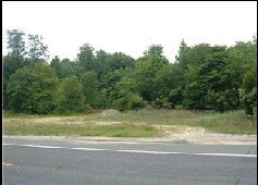
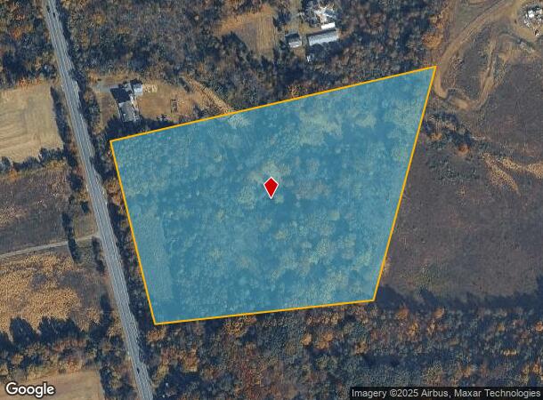
Property Record
246 Rt 68, Springfield, NJ 07081
NEARBY LISTINGS FOR SALE OR LEASE
-
-
View all Springfield listings for sale on LoopNet.com
Property Detail
246 Rt 68
34-02301-0000-00001-03-QFARM
Burlington
Farms
New Jersey
X
1.3
34005C0170F
14.98 AC
2024
South Burlington County
2025
Philadelphia
037602
Philadelphia-Camden-Wilmington, PA-NJ-DE-MD
DEMOGRAPHICS near 246 Rt 68
1 Mile
3 Mile
5 Mile
2024 Total Population
342
9,800
23,271
2029 Population
340
9,959
23,382
Pop Growth 2024-2029
(0.58%)
+ 1.62%
+ 0.48%
Average Age
43
42
39
2024 Total Households
120
2,630
6,826
HH Growth 2024-2029
0.00%
+ 1.37%
+ 0.32%
Median Household Inc
$139,526
$106,000
$99,496
Avg Household Size
2.90
2.80
2.90
2024 Avg HH Vehicles
3.00
2.00
2.00
Median Home Value
$509,434
$382,722
$395,832
Median Year Built
1982
1993
1992
Nearby Places
Map Layers
Map Styles
 Street
 Aerial
- Restaurants
- Banks
- Shops
- Fitness
- Groceries
PUBLIC TRANSPORTATION
AIRPORT
Trenton Mercer
DRIVE
WALK
Distance
Trenton Mercer
32 min
21.3 mi
Freight Ports
Port of Philadelphia
DRIVE
WALK
Distance
Port of Philadelphia
44 min
31.4 mi
Nearby Properties
Address
Land Use
TOTAL SIZE
Lot Size
Zoning
Address
Land Use
TOTAL SIZE
Lot Size
Zoning
Address
Land Use
TOTAL SIZE
Lot Size
Zoning
32 AC
AR3
Address
Land Use
TOTAL SIZE
Lot Size
Zoning
Address
Land Use
TOTAL SIZE
Lot Size
Zoning
3.33 AC
Address
Land Use
TOTAL SIZE
Lot Size
Zoning
Address
Land Use
TOTAL SIZE
Lot Size
Zoning
5.48 AC
Address
Land Use
TOTAL SIZE
Lot Size
Zoning
204 AC
AR3
Address
Land Use
TOTAL SIZE
Lot Size
Zoning
Address
Land Use
TOTAL SIZE
Lot Size
Zoning
Address
Land Use
TOTAL SIZE
Lot Size
Zoning
6.07 AC
Address
Land Use
TOTAL SIZE
Lot Size
Zoning
38.58 AC
Address
Land Use
TOTAL SIZE
Lot Size
Zoning
Address
Land Use
TOTAL SIZE
Lot Size
Zoning
18.09 AC
Address
Land Use
TOTAL SIZE
Lot Size
Zoning
138,300 SF
9.93 AC
Address
Land Use
TOTAL SIZE
Lot Size
Zoning
Address
Land Use
TOTAL SIZE
Lot Size
Zoning
1.67 AC
C
Address
Land Use
TOTAL SIZE
Lot Size
Zoning
1,000 SF
156 AC
AR3
Address
Land Use
TOTAL SIZE
Lot Size
Zoning
Address
Land Use
TOTAL SIZE
Lot Size
Zoning
Address
Land Use
TOTAL SIZE
Lot Size
Zoning
71,100 SF
8.90 AC
Address
Land Use
TOTAL SIZE
Lot Size
Zoning
4.36 AC
Address
Land Use
TOTAL SIZE
Lot Size
Zoning
Address
Land Use
TOTAL SIZE
Lot Size
Zoning
10.26 AC
AR3
Address
Land Use
TOTAL SIZE
Lot Size
Zoning
Address
Land Use
TOTAL SIZE
Lot Size
Zoning
625 SF
43.20 AC
AR3
Address
Land Use
TOTAL SIZE
Lot Size
Zoning
Address
Land Use
TOTAL SIZE
Lot Size
Zoning
Address
Land Use
TOTAL SIZE
Lot Size
Zoning
78.80 AC
AR3
Address
Land Use
TOTAL SIZE
Lot Size
Zoning
10.05 AC
GC
Address
Land Use
TOTAL SIZE
Lot Size
Zoning
The World's #1 Commercial Real Estate Marketplace
Connect with us
© 2025 CoStar Group
The information above has been obtained from sources believed reliable. While we do not doubt its accuracy we have not verified it and make no guarantee, warranty or representation about it. It is your responsibility to independently confirm its accuracy and completeness. Any projections, opinions, assumptions, or estimates used are for example only and do not represent the current or future performance of the property. The value of this transaction to you depends on tax and other factors which should be evaluated by your tax, financial, and legal advisors. You and your advisors should conduct a careful, independent investigation of the property to determine to your satisfaction the suitability of the property for your needs.